
The ocean has consistently served as a wellspring of grand narratives of endeavor and exploration. Our connection with the sea – encompassing work, play, love, loss, hope, and despair – plays a crucial role in shaping human identity, defining who we are as individuals and as societies.
You can uncover these grand tales of adventure at the National Maritime Museum, located in Greenwich, London – the largest and most frequented museum dedicated to seafaring in the world. Its extensive collection has inspired this book of puzzles, which will guide you on a journey around the globe.
This book features over 100 puzzles, many of which draw inspiration from the museum’s artifacts and their narratives, including maps, ships, nautical terms, explorers, myths, legends, iconography, and maritime traditions. The puzzles will challenge your general knowledge, observational skills, and interpretative abilities along the way.
You may navigate through the book in any sequence you prefer – there is no predetermined path on this journey! Some puzzles may present greater challenges, but you can always continue onward and revisit what you may have overlooked. By the time you reach the conclusion, you will have traversed centuries of history, crossed vast expanses of ocean, and made innumerable discoveries – so secure the hatches and embark on your voyage!

The objective of this questionnaire is to establish a standardized approach for collecting information about ships intended for the use of owners, operators, and charterers of vessels that transport liquefied gases in bulk, as well as for the terminals that handle such ships.
The phrase "Liquefied Gas Carrier" refers to vessels specifically engineered for the transportation of pressurized or refrigerated liquefied petroleum and chemical gases that possess a vapor pressure greater than 2.8 bar absolute at a temperature of 37.8°C, along with other products detailed in chapter 19 of the IGC Code, when transported in bulk, including those chemical carriers authorized for the transport of LPG and chemical gases.
While many owners already supply a ship information questionnaire, this document offers a suitable alternative where one is not available. The use of this questionnaire is entirely at the discretion of individual ship owners, operators, charterers, terminal operators, and other relevant parties.
It is anticipated that the Questionnaire will be completed in full only once during the lifespan of a ship, with minor adjustments to the recorded data being made as necessary should management, systems, or equipment undergo changes. Throughout the Questionnaire, if alternative responses are presented in the text, the response that does not apply should be removed.

As geologists gather information about the structure and character of the rock formations, they arrange it in graphic form. This not only helps them visualize what they cannot see directly, but also provides a way to communicate their findings to others. In particular, it helps them visualize and display the stratigraphy of the crust-information that describes the origin, composition, distribution, and succession of rock layers.
Maps, Sections, and Diagrams
Geologic information can be arranged graphically to show variation either horizontally or vertically. Horizontally arrayed data are maps; vertically arrayed data are sections. Sometimes these two types of arrays are combined in a simulated three-dimensional graph.
A geologist usually starts with a base map of the area of interest, showing survey benchmarks, property lines, and such non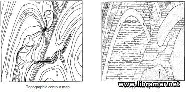 geologic surface features as streams, roads, and buildings. Base maps are useful for planning exploration, leasing, road building, well placement, and other activities.

This Nautical Almanac presents compilation of information prepared by Captain Roberto Iori. A great number of tables are intended to serve as valuable instrument for the navigator. The accuracy of the data contained in these tables has been numerously checked and confirmed; however, it cannot be fully guaranteed so you would better use them as a supplementary tool.
The information contained in the Almanac includes corrections to be applied to the observed altitudes of the Sun and of a fixed star, speed-time-distance table, apparent magnitude, conversion of arc to time, increments and correction tables, and other supplementary information. We strongly recommend students of marine navigation to download this Almanac and use it as a training tool.
The information carefully arranged by the author will definitely help them in their activities and also will be useful onboard ships and boats when used as the additional navigational publication. Just make sure you have a copy of the Almanac readily available at all times.

One more world popular and classic nautical publication. The content of this Almanac is traditionally arranged in several parts numbered for easier reference. The first part of the Almanac addresses the astronomical information and data that are commonly used every day by the navigators, together with the clear explanations on their use. The second part of the title is dedicated to the nautical tables and methods used.
The third part contains all required tables of tides for both home and foreign waters; the associated predictions were compiled by the recognized and reliable authorities. Then the part comes dealing with the coastal courses and distances covering the areas around the navigating channels of the British Isles and also near Europe. The fifth part of the Almanac contains the distance tables providing mariners with a worldwide coverage of the total distances between the major ports of US, Canada and Great Britain, and to all principal ports of the world.
The next part is dedicated to the legal issues, while the closing part of the volume deals only with the lights, buoys and beacons of the British Isles. The content of the publication has been carefully proofread and edited, and arrange in a way providing maximum accuracy and ease of reference. Another must-have one for literally every navigator.

The concept for this book originated from the requests of various insurance professionals, local institutes, and insurance companies who sought a single reference that encompasses essential information for enhancing the skills and knowledge of newcomers to the insurance sector.
Although titled The Marine Insurance Handbook, this book provides the guidelines utilized by marine underwriters and claims managers to make informed decisions on practical cases daily, grounded in established legal principles and rulings. It also features the most widely adopted insurance clauses issued by the Institute of Marine Underwriters and the Lloyd’s market, which are globally recognized and either derived from legal precedents or market consensus.
This book includes collections of the different Institute Cargo Clauses, comparing the 1982 and 2009 editions, as well as the Institute Time Clauses—Hulls and related clauses pertinent to ship insurance. Brief discussions on the well-known terms of the International Chamber of Commerce (Incoterms) are presented as relevant topics for cargo underwriting.
Additionally, the subjects of fraud, letters of credit (L/C), the relationships between banks and insurers, and protection and indemnity clubs are included, as they are deemed essential for underwriters and claims managers. Information regarding the various types of ships and the cargoes they carry is also provided, with a focus on the primary commodities transported by sea. International conventions that govern the carriage of goods by sea, land, and air are incorporated, as they hold significance for underwriters and marine claims handlers alike.
The topic of reinsurance is discussed, highlighting the major types of treaties employed in the market by small and medium-sized insurance firms. A summary of General Average and York-Antwerp rules has been included for necessary reference, while detailed information has been reserved for licensed loss adjusters.

This book emphasizes the relationship between shipping and the natural environment, exploring how the shipping industry can work towards greater sustainability. It provides readers with insights into marine environmental awareness, environmental regulations, and abatement technologies to aid in strategic, policy, and investment decisions.
You will become acquainted with various approaches to enhance environmental performance and, ultimately, to foster a sustainable shipping sector, grounded in an understanding of the origins and mechanisms of prevalent impacts. Additionally, you will acquire knowledge regarding emissions and discharges from vessels, preventive measures, environmental regulations, and methodologies and tools for environmental assessment.
Furthermore, the book features a chapter detailing the background of pollution regulation from ships. It serves as a valuable resource for professionals involved in maritime activities, policymakers, and the interested public. Moreover, it is designed to function as a textbook for higher education academic programs. Students and professionals engaging with this text may share a common trait: the drive to utilize reliable information to gain a deeper understanding and enhance performance.
This text aims to support contemporary mariners, environmental scientists, and regulatory administrators in this endeavor. By linking a concise historical overview of shipping and the environment with a fundamental introduction to environmental impacts, the book presents pollution prevention strategies centered on energy efficiency, discharge and emission controls, and tools for improved environmental management.
METAL CORROSION IN BOATS — THE PREVENTION OF METAL CORROSION IN HULLS, ENGINES, RIGGING AND FITTINGS

Metal corrosion and its prevention on boats is a widely misconceived topic that many boat owners, or boat builders write in their own way. Topics that are written about in yachting are often talked about in a way where only a corrosion engineer can only understand it's science and knowledge. Because of this, owners have found themselves seeking knowledge which has been made very difficult, and can now get a book of this sort to fill the gap.
It is good for an owner to have a good amount of knowledge of corrosion, in case they need it for metal boatbuilding as well as knowing the conditions that are appropriate for them to corrode. To make matters extremely important, the owners should take into account the safety. Choosing certain types of equipment can lead to problems, especially since chandlery folks aren't too knowledgeable regarding this topic. It is important to consider the topic of what can effect and interact with water is also important. It can be understood well without requiring the use of maths or any confusing science. However, there are theories out there that assist with finding a certain metal for a certain type of purpose. There are many factors that can effect how the corrosion of behaviour of metals so many rules are hard to follow.
It is known that metal has one main objective: to return to it's state (ores). Finding corrosion resistant items pays off great because of this. Spending more money will reward well. Choosing cheap material may have problems later on sinking the boat. Of course in writing information it is taken great consideration of different authors and their fields. And because there is experience between my boats from my work and naval architect, there may be a lot of information aired amongst practical boat owners with centreboard bolts.