Stratigraphy

As geologists gather information about the structure and character of the rock formations, they arrange it in graphic form. This not only helps them visualize what they cannot see directly, but also provides a way to communicate their findings to others. In particular, it helps them visualize and display the stratigraphy of the crust-information that describes the origin, composition, distribution, and succession of rock layers.
Maps, Sections, and Diagrams
Geologic information can be arranged graphically to show variation either horizontally or vertically. Horizontally arrayed data are maps; vertically arrayed data are sections. Sometimes these two types of arrays are combined in a simulated three-dimensional graph.
A geologist usually starts with a base map of the area of interest, showing survey benchmarks, property lines, and such non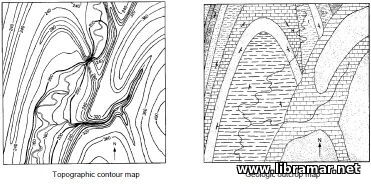 geologic surface features as streams, roads, and buildings. Base maps are useful for planning exploration, leasing, road building, well placement, and other activities.
Another type of surface map, a topographic map, displays land elevations as a series of contour lines, each line connecting points of equal elevation. A topographic map shows the geologist the shapes of hills and valleys, often revealing subsurface geologic structure by the pattern of exposed and eroded formations. The surface is described in a different way by an outcrop map, which shows the rock types at the surface or just beneath the layer of soil. Elevations and rock types are sometimes shown on the same map.
A contour map showing elevations of a subsurface rock layer or structure is called a structure contour map. This type of map is particularly useful in petroleum exploration because it shows, among other things, the topographic highs in porous formations where oil and gas are most likely to accumulate. Similarly, formation thickness can be delineated by an isopach map, on which contour 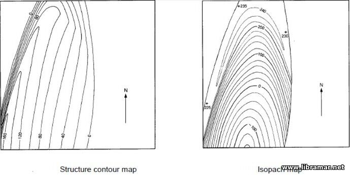 lines connect points of equal formation thickness.
Formation characteristics such as porosity, permeability, grain size, clay content, and cementation change from one location to another. A map showing such variations is called a lithofacies map. Here is a lithofacies map of a reservoir formation in which carbonates range from less than 20% to more than 70% of total rock volume. A petroleum geologist would find this map helpful in locating the part of the reservoir with the greatest production potential.
A section is a cutaway view showing the sequence of rock layers beneath the surface. Different formation characteristics can be displayed in a section, including rock type, vertical thickness, and elevation. A section can be constructed along either a straight line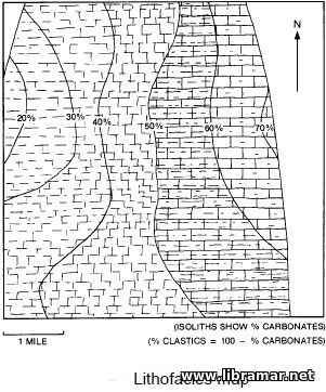 or a line connecting a series of points not in a straight line, such as drilled wells.
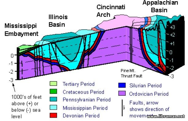
A block diagram combines the vertical presentation of one or more sections with the horizontal data normally displayed on a map. It may look very realistic, as though a piece of the crust were lifted out for examination. Usually, though, it is more abstract. A block diagram is useful for showing three-dimensional geologic data in the two dimensions of a sheet of paper or a video display terminal.
Principles of Stratigraphy
As mentioned before, stratigraphy is the study of the origin, composition, distribution, and succession of rock layers. The term encompasses the techniques used by the geologist to determine the succession of depositional environments and the relative ages of rocks.
A sedimentary layer is deposited in a continuous, unbroken sheet with an essentially horizontal upper surface but a lower surface that conforms to a previous land surface or seafloor. Its edges "lap out" like water at the shore of a lake. Each layer is deposited on top of older sediments; in an undisturbed series of rock layers, the youngest layer is at the top and the oldest is on the bottom.
 Once a sedimentary rock layer is formed, its continuity or horizontally may be disrupted in a number of it may be partly eroded; it may be fractured, faulted, bent, or folded by crustal movement; it may even be invaded by magma that cools to form a subsurface body of igneous rock.
Just as any formation is known to be younger than the formation beneath, any event that disrupts the continuity or horizontally of a formation is more recent than the deposition of the layer affected. Similarly, any layer that cuts across another layer must have been deposited after the layer it cuts and is therefore younger.

The "Read Later" function allows you to add material to this block with just one click. Just click on the icon and read the articles that interest you at any convenient time.