Route Planning with ECDIS

What is voyage planning, who is responsible, how do we comply with the rules and how do we utilize the features and functions available in an ECDIS? The purpose of voyage planning is to support the bridge team and ensure that the ship can be navigated safely between ports from berth to berth. A voyage plan should cover ocean, coastal and pilotage waters and according to STCW regulations be planned in advance. The voyage plan aim to establish the most favorable route while maintaining appropriate margins of safety and safe passing distances offshore.
The following factors are amongst those that should be taken into account:
- - The marine environment
- - The adequacy and reliability of charted hydrographic data along the route
- - The availability and reliability of navigation aids, coastal marks, lights and radar conspicuous targets for position fixing along the route
- - The type of cargo can influence route selection
- - Any routing constraints imposed by the ship, e.g. draught, type of cargo, etc.
- - If possible, avoid areas with dense traffic
- - Take into account weather forecasts, current, tide, wind, swell and visibility conditions
- - If possible, avoid areas with onshore set or areas where onshore set can be expected
- - Whenever possible, follow traffic separation schemes and follow ship reporting procedures
- - Check technical systems before departure and if possible, take into account previous experience of their reliability
- - Take into account your own experience with the planned route and type of ship.
There are four main stages in the planning of a safe voyage: 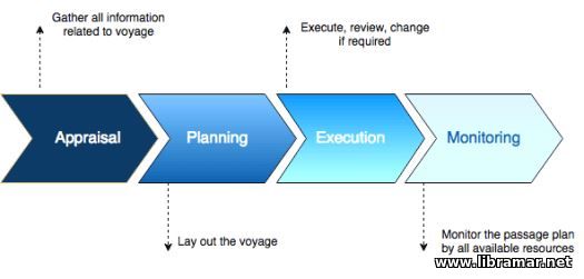
- - Appraisal, i.e. the collection of information and validation of all relevant information;
- - Planning, i.e. the presentation of the raw data into information and the strategy to be used;
- - The execution of tracking, voyage and communication control;
- - Monitoring, i.e. ensuring that the voyage plan is being followed.
Voyage planning can be done the traditional way by using up-to-date paper charts and other relevant nautical information. If the ECDIS with approved and updated electronic navigational charts is available, such a system offers many possibilities for professional and efficient voyage planning.
Below, a description of functions which may be found on an ECDIS is described:
Base display – represents the minimum amount of information permitted in a chart on the screen; a typical base display shows the coastline, traffic system and indication of sub-sea dangers, while the standard display show, in addition to the above, the chart boundary, aids to navigation, and caution areas and notes.
Most ECDIS systems can operate in two route monitoring and route planning modes:
- - A route plan is a description of how a voyage is to be carried out.
- - A waypoint is a position where the ship’s course is to be changed.
The line connecting two waypoints is referred to as a leg.
In an ECDIS every stored route and waypoint gets its own unique identifier.
A ship’s course change can be described in detail by specifying the turn radius.
The off track limit specifies a distance on both sides of the course line.
The decision where, on a given course line, the next way point should be selected, can under certain circumstances be decided by:
- - A certain distance to a known mark
- - Two marks observed through a straight line
- - The route name, the start time for the route and waypoints may be included in the route plan.
For each waypoint the following information may be inserted:
- - The waypoint name
- - The position, longitude and latitude
- - The wait time at waypoint
- - The turn radius
- - The message
- - The turn point
- - The off track limit
- - The cruise speed
- - The max speed.
Based on these data the ECDIS system can automatically calculate: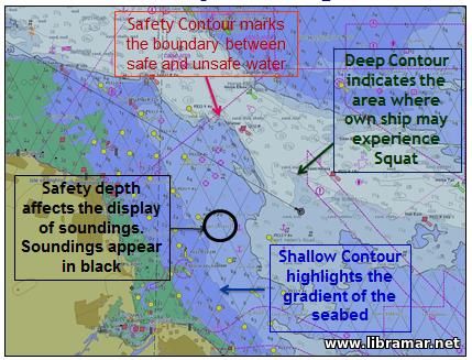
- - The number of waypoints of the route
- - The estimated time of arrival
- - The course and length of each leg.
Waypoints and corresponding data can be changed or removed. Waypoints can easily be moved on the chart. When a waypoint is moved, the part of the route that is affected is changed correspondingly. This means that it is easy to see the consequences of moving a waypoint.
Some ECDIS systems on today’s market can import and export electronic charts and routes to and from integrated navigation systems. The safety contour is a line in the chart that defines water with safe depth in relation to the actual ship. The ECDIS system continuously checks if the ship, within a specified time may cross the safety contour and if so, gives an alarm.

The "Read Later" function allows you to add material to this block with just one click. Just click on the icon and read the articles that interest you at any convenient time.