 The rig floor is the business end of the drilling machine. It is the place where the drilling operation is controlled and where accidents and disasters can be prevented. The rig floor area is under the command of the Driller, the most important person on a drilling rig, because he is the person with the hands on the controls for the drilling machine and also receives alarms and signals from the well directly on his various control panels. The Driller is in charge of the rig crew. He reports to his supervisors which is the Tourpusher and Toolpusher.
A lot of planning is included when building a new drilling rig. The result is often an improvement over existing rigs. When a rig floor is designed there is often collaboration between Drillers, Rig Owner, Engineers and other people with a vested interest in the success of the project.
The layout must consider a number of criteria, including “must do” and “must not do” as well as “need this” and “got to have that”. It is like designing a dream home, everything has to fit perfectly and compromises are only acceptable in the small claims department.
The main elements on and around the rig floor include:
• Doghouse – The drillers control room, where all the main controls for the rig floor area is located.,
• Drawworks – the power winch that lift or lower s drill string into the well. Part of hoisting system which includes mast or derrick, Drill line, Crown block with sheaves, Travelling block with sheaves and finally the drill line and anchor., s drill string into the well. Part of hoisting system which includes mast or derrick, Drill line, Crown block with sheaves, Travelling block with sheaves and finally the drill line and anchor.,
• Derrick/Mast – Supports all the weight of the drill string and allows lengths of pipe to be lifted or lowered into the well and allows racking of lengths of tubular to be racked (stored) in stands when not in use.,
• Rotary table – Where the drill string enters the hole and where slips and other tools are used to suspend drill string and add or reduce number off tools to be run into the hole.,
• Pipe handling equipment – “Automatic” addition or removal of stands from drill string sometimes including stand building capacity.,
• Iron Roughneck – Machine used for Make-up or break-out of tubular in the drill string. Removes the dangerous use of manual operation with rig tongs.,
• Rig tongs (Manual) – Manual tong used for make-up or break-out of tubular in the drill string.,
• BOP control panel – Where the Driller controls the Blowout Preventer Stack. It allows the Driller to close-in the well.,
 There are quite a few instruments for the Driller to observe and control and quite a few of the instruments/gauges and buttons seems to be added to the initial set-up giving the overall impression of the cabin as being cluttered and confusing. This is unfortunately quite often the picture of a Drillers Cabin, or Dog house. All sensors and data required for the driller are available on the two screens. There are quite a few instruments for the Driller to observe and control and quite a few of the instruments/gauges and buttons seems to be added to the initial set-up giving the overall impression of the cabin as being cluttered and confusing. This is unfortunately quite often the picture of a Drillers Cabin, or Dog house. All sensors and data required for the driller are available on the two screens.
The concept of operating a drilling rig entirely just by two joy-sticks and two screens can be a challenge to the older generation of drillers. They do not like to rely solely on a computer manufacturer to make all the rig safety devices work. Especially when talking about well control equipment (BOP). But this is the future and it creates even higher demands on rig crew competencies than ever before.
Rig crews in the future must be multi-skilled specialists trained to work with and maintain special equipment and tools not seen in any other industry. Additional equipment usually placed on the rig floor or in the immediate vicinity includes:
• Air winches – Winches either air- or Hydraulic driven with a load range approx. 10000 lb. used for lifting pipe to the rig floor from the pipe deck or used for lifting heavy things around on the rig floor or even for lifting and hang off equipment in the Derrick. One type of air winch must also be available on the rig floor and this is a winch which must be used for lifting personnel and only be used for this purpose.,
• Standpipe manifold – A system of valves piping and connections used for routing drilling fluid piped up from pump room to standpipe(s) in the Derrick into the mud hose (Kelly hose) through the swivel and down the drill string.,
• Choke manifold – A system of valves piping and connections used in well control situations where BOP is closed and mud and well bore fluids coming from the well (Annulus) are routed from the BOP up the choke line to the choke manifold and then through the choke and the Mud/gas separator where gas is removed from the mud and then over shale shaker and to the mud process tanks.,
• Pipe rack – Racking area on the pipe deck. On a land rig special racks are built so that pipe can be rolled right onto the catwalk and the hoisted to the rig floor. Horizontal pipe storage area for pipe or casing.,
• Catwalk – Movable walkway where pipe is landed when removed from rig floor to pipe deck storage or vice versa. This walkway is also attached to the V-Door ramp which is the slide coming from rig floor towards pipe deck.,
The rig floor has to accommodate all these tools and equipment and it is even more complicated by the fact that electrical systems may have to be explosion proof. This includes making the equipment electrically safe and spark proof to prevent accidental fires and explosions if gas or oil leaks out of the well. EX proofing is expensive and under stringent requirements and special training is required for electricians working with this type of equipment. fires and explosions if gas or oil leaks out of the well. EX proofing is expensive and under stringent requirements and special training is required for electricians working with this type of equipment.
It is an amazing engineering feat to see the complex jumble of high-pressure piping, air lines, mud hoses, hydraulic hoses/piping and electrical wiring fitted underneath the rig floor and terminating up through the rig floor in just the right place.
 Ever since man started to dig holes in the ground, searching for salt, fresh water and minerals, there has been a continuous development. In digging technology, the first wells were dug by hand and as one got deeper, the wells were lined with rocks and wood to prevent them from collapsing.
When entering the oil-bearing zones, fumes and gases started to interfere with “digging”. It became necessary to drill rather than dig and this was the start of the oil drilling industry.
All types of drilling, whether it is for water, minerals or oil, have to abide the laws of physics. It is therefore no coincidence that most of the drilling techniques developed in the different areas of the world, are quite similar. Although a mining rig looks very different from and oil drilling rig, they perform the same function, namely “drilling a usable hole”. Drilling for oil and gas successfully is a process that requires a number of skills and a lot of advanced equipment. As the drilling process becomes more complicated, the drilling tools and the way they are used, must also be updated.
The oil industry began over five thousand years ago. In the Middle East, oil seeping up through the ground was used in waterproofing boats and baskets, in paints, lighting and even for medication.
Whale oil has been used in more recent times as a source of light in houses. However, the high premium for whale oil decimated whale populations and as their numbers dropped the prices rose further.
The demand for oil was now far higher than the supply. Many companies and individuals were looking for an alternative and longer lasting source of what would later become known as black gold. Apart from a brief period of coal oil, the answer came with the development of drilling for crude oil. Land oil wells were first and as demand continued to grow exploration companies began to look below the sea bed.
The first oil well structures to be built in open waters were in the Gulf of Mexico. They were in water depths of up to 100m and constructed of a piled jacket formation, in which a framed template has piles driven through it to pin the structure to the sea bed. To this, a support frame was added the working parts of the rig such as the deck and accommodation. These structures were the fore-runners for the massive platforms that now stand in very deep water and in many locations around the world, including the North Sea. How did they know to look for oil beneath the North Sea? In 1959 the massive Groningen land gas field was discovered in the Netherlands. Geologists estimated that the same rock formations might be found beneath the southern North Sea basin in UK  waters. They were right and gas was discovered of the English East Coast in the 1960s. waters. They were right and gas was discovered of the English East Coast in the 1960s.
Clues around the coast of Greenland gave Geologists the idea that there may be oil and gas around Scottish waters.
There have been land oil wells in Europe since the 1920s. It wasn't until the 1960s that exploration in the North Sea really begun, without success in the early years. They finally struck oil in 1969 and have been discovering new fields ever since. The subsequent development of the North Sea is one of the greatest investment projects in the world.
The development of the offshore oil industry in hostile waters has been made possible by many achievements comparable with the space industry. Many fields are located far from land and they are getting further away. New fields are being explored in ever deeper and wilder waters, like the Atlantic Ocean west of Scotland.
After the North Sea UK disaster in 1988 when on 6 July, the North Sea Piper Alpha oil platform caught fire and exploded killing 167 of the 228 on board. The industry and the government waited until 1990 for the publication of the Cullen report. Lord Cullen discovered that the main cause of the explosion was the failure in the operation of the permit to work system, for which there are now very strict guidelines. This system is used to over-sea work, preventing potentially dangerous work being carried out. It also prevents dangerously conflicting work being carried out by a combination of workers and it ensures that proper laid down procedures are adhered to. The report brought about many changes and a journey towards much greater safety awareness, procedures and regulations. 167 of the 228 on board. The industry and the government waited until 1990 for the publication of the Cullen report. Lord Cullen discovered that the main cause of the explosion was the failure in the operation of the permit to work system, for which there are now very strict guidelines. This system is used to over-sea work, preventing potentially dangerous work being carried out. It also prevents dangerously conflicting work being carried out by a combination of workers and it ensures that proper laid down procedures are adhered to. The report brought about many changes and a journey towards much greater safety awareness, procedures and regulations.
Today the industry is very safety conscious. It has to be for its very survival. For example, the safety record of an exploration rig can make a big difference to whether or not an oil company will want to hire it. Oil companies cannot afford to have their name associated with accidents.
When you first arrive, you are given a tour of the installation, detailing all safety aspects including fire extinguishers, emergency muster stations, lifeboat stations and procedures. You will be introduced to the rig safety programme.
Everyone attends weekly safety meetings and daily pre "tour" meetings. The weekly meeting is an in-depth look at industry wide safety news and other safety related issues on the rig. Companies share safety information with other companies throughout the industry. This helps to avoid repeated incidents. A fire and boat drill are often held on the same day which involves a mock fire and a mock abandon the rig exercise. The pre-tour meeting is usually a description of the work carried out when you are off shift, the work you will be doing, the work others are currently doing that may affect you and any other relevant issues of the day.
Accidents do happen as in every industry. However, statistics show that with the massive improvements in offshore safety procedures, you now have a higher chance of having an accident if you work on a building site than you do on an oil rig.
Petroleum or crude oil is an oily, flammable liquid that occurs naturally in deposits, most often found beneath the surface of the  earth. Over millions of years, plant and animal remains fall to the floor of shallow seas. As the seas recede, the plant material is covered by sediment layers, such as silt, sand, clay, and other plant material. Buried deep beneath layers of rock, the organic material partially decomposes, under an absence of oxygen, into petroleum that eventually seeps into the spaces between rock layers. As the earth's tectonic plates move, the rock is bent or warped into folds or it "breaks" along fault lines, allowing the petroleum to collect in pools. Man was not unfamiliar with crude oil. In the Middle East, seepages and escaping petroleum gases burned continuously, giving rise to fire worship. It was also used for building mortar, roads, in a limited way for lighting, but was primarily used for healing everything from headaches to deafness. It was also used in war, for obvious reasons. earth. Over millions of years, plant and animal remains fall to the floor of shallow seas. As the seas recede, the plant material is covered by sediment layers, such as silt, sand, clay, and other plant material. Buried deep beneath layers of rock, the organic material partially decomposes, under an absence of oxygen, into petroleum that eventually seeps into the spaces between rock layers. As the earth's tectonic plates move, the rock is bent or warped into folds or it "breaks" along fault lines, allowing the petroleum to collect in pools. Man was not unfamiliar with crude oil. In the Middle East, seepages and escaping petroleum gases burned continuously, giving rise to fire worship. It was also used for building mortar, roads, in a limited way for lighting, but was primarily used for healing everything from headaches to deafness. It was also used in war, for obvious reasons.
 In discussing the components of the earth's crust, it is important to distinguish between rocks and minerals. A mineral is a naturally occurring crystalline substance of a definite range of chemical composition. A rock is a mixture of minerals, usually in the form of grains that may be easily visible or microscopic. The most common rock minerals are silicates-crystalline compounds composed largely of silicon in chemical combination with aluminium, magnesium, oxygen, and other common elements.
Igneous rocks are those that cool and solidify from a molten state. They are classified by chemical composition and grain size. These characteristics, in turn, depend on the elements present in the magma and on how long they cool-the longer the cooling time, the larger the crystals.
Rocks that are exposed at the surface of the earth are subject to weathering by climatic agents, especially water. Water breaks down solid rock by changing it chemically, by dissolving some of its minerals, by supporting the growth of plants and animals that grow on and around rock, and by freezing and expanding to wedge the rock apart. Running water then carries fragments of rock and soil to sedimentary basins-low places where sediments can accumulate, sometimes to a depth of several miles. The weight of the accumulating sediments compresses and bonds the deeper beds into layers of sedimentary rock.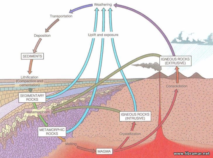
Any type of rock that is buried deeply enough or otherwise subjected to great pressure, stress, or heat can become transformed both chemically and physically into another kind of rock: metamorphic rock. For instance, shale, a crumbly sedimentary rock made of clay, can be changed by heat and pressure into hard metamorphic slate. Slate, or any other rock, can in turn be heated until it melts and then cooled into fresh igneous rock, or it can be broken down by weathering so that it contributes to the formation of new sedimentary rock. The principles involved in the transformation of one type of rock into another are illustrated by the rock cycle.
Two of the most important characteristics of sedimentary rocks, attributes that are rarely found in igneous and metamorphic rock, are their porosity and permeability.
Porosity is the amount of empty space present within the rock; it is usually expressed as a percentage of total rock volume.
Permeability is a measure of the ease with which a fluid flows through the connecting pore spaces of a rock; the more connections between pores, the higher the permeability.
Porosity and permeability are of supreme importance to the geologist in determining whether a body of rock can contain petroleum and whether that petroleum can be extracted and brought to the surface.
 The young earth's molten surface was in constant motion, like the lava in an active volcano today. As a solid crust began to form, it was carried about on the surface by the moving magma beneath. Although this crust has grown thicker and stronger over time, it is still in motion atop the moving mantle.
The crust is divided by a world-wide system of faults, trenches, and mid ocean ridges into six major plates and many minor plates that fit together like the pieces of a jigsaw puzzle, as you can see on the image.
These plates, however, move and change shape. In some places, they slide past one another; in others, they collide or move apart. The theory that explains how these processes work to shape the crust is called plate tectonics. apart. The theory that explains how these processes work to shape the crust is called plate tectonics.
The earth's surface consists of two kinds of crust. Oceanic crust is thin (about 5 to 7 miles) and dense. The rock that makes up the continents, however, is thick (10 to 30 miles) and relatively light. A continent rises high above the surrounding oceanic crust and extends deeper into the mantle-like an iceberg in a frozen-over sea.
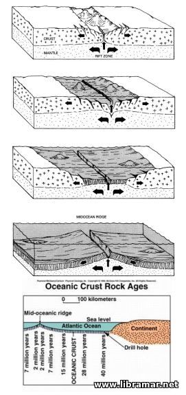 Sometimes a plate splits and begins moving apart. This is the way ocean basins are formed. The picture on the left shows a rift forming in the middle of a continent. As the two parts of the continent pull away from each other, magma rises from the mantle and solidifies in the gap, forming a mid ocean ridge. New crust being thinner but denser than the continents spreads outward between the two "daughter" continents. The Atlantic Ocean was born in just this way about 200 million years ago when North and South America split away from Europe and Africa. Sometimes a plate splits and begins moving apart. This is the way ocean basins are formed. The picture on the left shows a rift forming in the middle of a continent. As the two parts of the continent pull away from each other, magma rises from the mantle and solidifies in the gap, forming a mid ocean ridge. New crust being thinner but denser than the continents spreads outward between the two "daughter" continents. The Atlantic Ocean was born in just this way about 200 million years ago when North and South America split away from Europe and Africa.
Where plates meet head on, several things can happen. If oceanic crust meets oceanic crust, one plate is subducted that is, it slips beneath the edge of the other plate and descends into the mantle, forming a trench in the ocean floor. The descending plate is melted by the hot mantle in the subduction zone. Some of its minerals melt at lower temperatures than others and rise through the crust as magma, which may either cool and solidify within the crust, forming igneous rock such as granite, or reach the surface as volcanic lava.
If one of the converging plates is made up of continental crust, it overrides the heavier oceanic plate, which bends downward in a trench along the continental margin. When this happens, magma from the descending plate may erupt in continental volcanoes like Mount St. Helens. If both of the plates are continental, the collision buckles and folds the rocks including the sedimentary rocks at the edges of the continents-into great mountain ranges like the Himalayas.
 Geologists now obtain close estimates of the age of rocks by measuring their radioactivity. Naturally occurring radioactive elements, such as uranium, change at a measurable rate into other elements, such as lead. By measuring the proportions of different forms of lead, scientists can tell about how much time has passed since a rock was formed. Using such methods, geologists have radically changed our ideas about the age of the planet.
Even the ten million years that it took to carve the Grand Canyon is but the most recent moment of geologic history. The earth was formed about 4.6 billion years ago when frozen particles and gases circling a new yellow star were brought together by mutual gravitational attraction. Heated by compression and radioactivity, this material formed a molten sphere.
The heaviest components, mostly iron and nickel, sank to the center and became the earth's core. Lighter minerals formed a thick, molten mantle, while minerals rich in aluminum, silicon, magnesium, and other light elements cooled and solidified into a thin, rocky crust./span>
The surface of the young planet was an inhospitable place. Molten rock (magma) erupted everywhere through fissures and volcanoes, expelling the gases and water vapor that formed the early, oxygen less atmosphere. As the surface cooled, rain condensed and fell in torrents, and the first oceans began to form.
The earth was devoid of life for perhaps its first billion years. Eventually, out of a mixture of complex carbon-chain chemicals, the first self-replicating molecules appeared in the ocean, perhaps in the muck of some shallow lagoon. Over millions of years these primitive organisms grew more complex and varied, first as single-celled bacteria like forms, later as microscopic protozoa and algae. Some grew in the form of colonies, which over further millions of years evolved into more complex organisms. As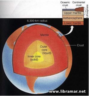 photosynthetic single-celled plants, which used carbon dioxide and gave off oxygen, became more abundant, their waste oxygen became a major constituent of the atmosphere. photosynthetic single-celled plants, which used carbon dioxide and gave off oxygen, became more abundant, their waste oxygen became a major constituent of the atmosphere.
Few traces of this early life survive, however. Although plant remains and impressions of primitive organisms can be found, it was about 4 billion years before animal life became abundant enough (and developed body parts durable enough) to leave significant numbers of fossils. This early, fossil-poor period, comprising most of the time since the earth formed, is commonly known as the Precambrian era.
The last 600 million years of earth's history comprise the time of abundant life. The first fish appeared about 500 million years ago in the early Palaeozoic era, followed by the first land plants, amphibians, and reptiles. The Mesozoic (220 to 65 million years ago) was the era of the dinosaurs, early mammals, and primitive birds. And the Cenozoic era embraces the time from the extinction of dinosaurs through the recent ice ages to the present.
 Here on the right you can see a cross section of Earth illustrating the core; mantle and crust. The enlarged position shows the relationship between the lithosphere, composed of the continental crust, oceanic crust and upper mantle and the underlying asthenosphere and lower mantle. Here on the right you can see a cross section of Earth illustrating the core; mantle and crust. The enlarged position shows the relationship between the lithosphere, composed of the continental crust, oceanic crust and upper mantle and the underlying asthenosphere and lower mantle.
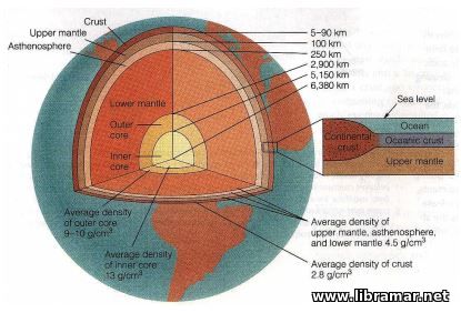
And on the left, have a look at the cross section of Earth showing the various layers and their average density. The crust is divided into a continental and oceanic portion. Continental crust is 20 to 70 km thick, oceanic crust is 5 to 10 km thick.
 Let us have some talk about the offshore exploration of the hydrocarbons, i.e. oil and gas, in general. We are so happy to introduce the series of articles shedding some light on this interesting subject.
The readers will get to know so much more about the basic geology for a start, and after that we will start diving deeper and deeper in the drilling equipment and technology, from the very beginnings and up to such modern types as directional drilling. All systems and machinery pieces on board rigs will be explained in detailed, with the supporting images and videos, whenever required.
Spend some time reading these articles and make sure you have checked all of them, and we promise that you will see that your knowledge and understanding of the drilling technology and associated equipment and techniques has sufficiently expanded.
In the petroleum industry, which finds and recovers oil and gas from deep within the earth's crust, geology is fundamental. Petroleum occurs mostly in isolated, hard-to-find accumulations. The scientific study of the earth's history and its life, especially as recorded in the rocks of the crust, reduces the risk of drilling dry holes and lowers the cost of production by helping determine the most efficient way of drilling a well.
Knowledge of geology increases the total supply of petroleum by helping recover more of the resource in place. Petroleum geologists are most concerned with rocks formed in the earth's surface by processes closely associated with both climate and life. The way these rocks are created and changed, as well as how oil and gas form and accumulate in them, are the principal concern of the petroleum geologist. For a thorough understanding of these processes, it is necessary to look back in time-first, to the beginning of the modern science of geology; then, to the beginning of the earth itself.
Ancient geologists believed that the earth had been created all at once, complete with all its mountains, canyons, and oceans, in a single great cataclysm. In the 1700s, though, scientists began to understand that familiar natural processes, such as the accumulation and erosion of sediment, and "minor" cataclysms, such as earthquakes and volcanic eruptions, could account for all the features of the earth's crust-given enough time. Thus the doctrine of catastrophism was eventually supplanted by the theory of gradualism or uniformitarianism meaning, as Scottish geologist James Hutton put it two centuries ago, that "the present is the key to the past."
This concept of gradual change is central to modern geology. Today's geologists know that the Grand Canyon is the work of a powerful erosive agent, the Colorado River, over some ten million years, as you can see on the picture; that the Himalayas and the Sierra Nevada are growing loftier by a fraction of an inch each year, and have been doing so for millions of years; that Africa and America are moving away from each other about as fast as a fingernail grows.
 In the United States, all offshore oil and gas operations began in the late 19th century. It was Edwin Drake who drilled the very first oilwell in the America in 1859. He did it on a piece of land near Titusville, Pennsylvania. It was only thirty-eight years later, in 1897, that another enthusiast drilled the first offshore well in U.S. He drilled it offshore Southern California, immediately south of Santa Barbara...
In the late 1800s, a group of people founded the town of Summerland, California. The founders picked the site because of its pleasant, sunny climate. Coincidentally, it also had numerous springs. These springs did not, however, produce water; natural gas and crude oil bubbled out of them...
|